Kouchi-Kouchi-2

Alas, our stay at Kouchibouguac is drawing to a close…. The TwoLeggs have had quite a time with the bikes! Each day has brought another variation of trails that the Park has to offer, with hints of the trails that interconnect throughout much of the Province. Yes, Canadians apparently love their bicycles!

In addition to the bearly visible wildlife sightings, our rides have offered a few mechanical interests. Along one outing, a good 4-5 miles out, Carlos’ bike, under a mammoth uphill effort, blew out a flip-flop (as my good buddy, Jimmy would say), and sent his back wheel crooked. No wheel damage, fortunately, but the tire remained misaligned making for a slow go home. Repairs were made.

Not to be outdone, a day or so later, Minkie tried a similar move, but her gears operate a little differently (hers are from Venus, or so they say) so to chain-ge things up a bit, she popped hers. Fixable, but my, what a greasy mess!

Lucky for the Toad, his bike suffered no such maladies, though I did grow a bit tired of watching the TLs mess things up! I almost SPOKE up, but didn’t, as it was g-rim enough as it was. OK, no more puns for the minute.

Instead here are a few of the places we visited –

The Marina:

Riding along the coastal trail, near Kelly’s Beach:

Checking out the salt marsh:

Riding in the woods:

And of course, the iconic Red Chairs of Canada’s National Parks:

From here – Look out Annie Green! We’re off to Prince Edward Island!

Kouchibouguac National Park – New Brunswick, Canada

If you’re a Road Toad who happens to like a park that has really nice, large, well separated (read – private!) campsites; and said park also offers a beach on the ocean, miles of bike trails, lots of activities for the wee ones, amenities such as a camp store, laundry, and concession stand; AND is a dark sky preserve….. Well you might want to put this one on your list. While the name is a bit intimidating, the park is not. And it is a riot for my TLs, who have never taken bikes with them before! We are having a blast!

Part of the park offers a small tribute to the first people of the area – the Mi’kmaq Indians who lived here before the French, English, Scottish, etc entered.

But the majority of the park focuses on its surroundings – the ocean, the forest, their inhabitants, and of course, the sky above. So far, we’ve not had a chance to enjoy the night sky – clouds have been a consistent visitor, obstructing our view of the cosmos. I’ve suggested that they might want to go elsewhere for a night a two – we’ll see what the next few nights bring.

But as to those forest inhabitants, we went for a lovely ride through the park, encountering no one, save for this youngster:

And tonight, we had some of the best pizza EVER! Half a veggie delight (for Minkie, of course) and half a supreme (for Carlos) – and naturally, the Road Toad had to sample both. I was NOT disappointed. Nay, even for a lover of bugs, this was a pizza to tingle the taste buds. Along with some local brews, ensconced atop our zero-gravity recliners, tucked inside the screen room (where of course, I gobbled up the stray mosquito or fly that happened in), we were a trio that could hardly have been any happier.

Happiness to you all, too!

Back to New Brunswick

Our final day in Forillon was a cloudy, blustery, cool day with rain a constant threat. We decided to visit the north side of the park, which we had glimpsed from a distance at several observation points along the mountain hikes. Off to Cap Bon Ami, which was busy, but not obnoxiously so, given the weather. This too, is a location that puts you in awe of the ruggedness of the area – beach rocks rounded and smoothed by the constant tumbling in the crashing surf. Overhead, gannets soared. Seagulls called. The TwoLeggs ate a picnic lunch, and I wandered about and snapped a couple of pictures of the views in either direction….

And of course, we had to stop at Cap-de-Rosiers (Cape of Roses), to see the lighthouse there:

Adieu, Forillon!

Up next: another Dark Sky Perserve in New Brunswick: Kouchibouguac National Park. As we made our way from Forillon along the coast of the Gaspe Peninsula, we couldn’t help but marvel at the impressive, ever present magnificence of the shoreline beauty. Everywhere there are cliffs, rock formations jutting from the water, islands in the distance, and of course, sea life. Perhaps the most famous of these is the Rock of Perce, that sits between the town of the same name and Bonaventure Island – home to an impressive migratory bird sanctuary – where one can view colonies of Northern Gannets, Black-legged Kittiwakes, common Mures, Cormorants (Great and Double-crested), Herring Gulls, Razorbills, and other migratory birds.

Birds, marine mammals, forests leading to water/cliffs edge, beach roses, wildflowers – there seemed to be no end to the color and variety as we worked our way south. Even the TwoLegg towns and villages – many of them working communities – find pride in their surroundings: litter isn’t present. Flowers brighten window boxes and driveways; even advertising – where you find it – seems unobtrusive, not wanting to detract from the natural beauty of the area.

Yes, we will miss the Gaspe Peninsula quite a bit. And we will all miss hearing French spoken everywhere. Carlos and Minkie got quite a kick out of practicing the few phrases they knew, and learning new words and expressions. Carlos, in particular, would probably become somewhat proficient in no time at all, given the chance to stay a while longer. (The Toad of course, admits this with grudging admiration!)

Adieu, Quebec!

Sentier Les Cretes – Forillon NP, Quebec

So, you think that this is la destination du touristes? Don’t be so sure! I took Carlos and Minkie on a very different trail today. Shunning the usual places where most folks venture, off we went for a little exploration along the International Appalachian Trail. Wait a sec – did you say Appalachian Trail? Aren’t we in CANADA? Yes, my fellow Toads, we are in Canada. And for a refresher, the Appalachian Mountains don’t stop in Maine! They start way down in Alabama, and extend into Canada, ending (of all places) here in the Gaspe Peninsula. And the Appalachian Trail (which starts on Springer Mtn. Georgia, and ends at Mt. Katahdin, Maine), has an international component. Picking up at Katahdin, it continues northward into Canada as the International Appalachian Trail (or the Sentier International Appalachian) through Mount Carlton, and into Quebec, ending here in Forillon National Park. Very Impressive!

We started at a section about a third of the way along, and headed first to the west, up to a spot where twin overlooks sit high on a ridge – offering breathtaking views of both the Gulf of St. Laurence, and the Gaspe bay.

That’s me – taking in the sights of the Gaspe Bay!

We liked this trail enough to go a second day and explore the trail’s beginning on the western side of the park. The Crests Trail spans about 11 miles or so, and offers a good workout, regardless of where you join it. It is not a tourist attraction (no whales, seals, or lighthouses here), so far fewer folks make use of it. And yet it is a takes you through gorgeous forests and offers wonderfully scenic overlooks high on the ridge. Yes, the trail is rated difficult, but the Toad suspects this is due mostly to the length of the climb up to the ridge. Here the forest is largely birch and balsam, and oh how wonderful to smell the balsam!

Now, realize that part of the reason this is less traveled is because a spell has been cast to keep out all but those who have purpose here. For this path wanders through the land of the wood sprites. You can hear their music in the birds’ songs, their whispers in the wind, and their laughter in rustling leaves. These are happy folk, who, if you are friend, will keep you entertained as you walk, and safe until you reach your destination. They ask little in return – tread carefully, marvel at the beauty of their homeland, and take with you only pictures and memories.

No bear did we encounter on this trek; no moose wandered by. But there is much to be seen, much to enjoy!

Yes, this is an unusual, stunning part of the world to visit! Well worth the time it takes to get here, and well worth taking the time to drink it all in!

Next up, a little bit of light to shine the way….

Bout du Monde (Land’s End) – Forillon NP, Quebec

Morning beckoned my TwoLeggs early – to ensure a place to park the Beast, that we might walk the trail to Lands End – that furthest spit of land in this most marvelous of places. After a quick bite, off we went – in hopes of seeing some marine mammals as we worked our way to the terminus of cliffs. We were not disappointed.

The trail itself is relatively easy, and about 3 miles or so from where we picked it up to its end. It’s rated moderate, I believe, but only because there are a few stretches that give the legs a good work out. Nothing overly obnoxious though. And the rewards are plenty. It travels first along the cliffs overlooking Gaspe Bay, much of it open to the wonder of so much blue water.

Overhead, gannets soared. Seagulls called. And then, the path leads away, up into the forest. Here, high along the ridge, we heard that most distinct sound of a whale surfacing and blowing. Luckily, an overlook appeared just ahead, and sure enough, way out down below – we saw her – a grey whale, entertaining anyone who cared to watch. We were too far away for pictures (and who, Minkie, left her camera back with the Beast???), but we are all thrilled to have been able to see such a magnificent creature.

Work your way a little farther along, and before you know it – here you are!! You emerge from the forest to the sight of the Cap Gaspe Lighthouse – which has been in operation in one of three iterations, since 1873.

Because it sits atop a cliff 950 meters above the sea, it’s not the tallest lighthouse around – but it is certainly a powerful little fella, sending its light out 15 nautical miles (all that’s needed these days, given modern electronics). And, like all of its kin, it has its own calling signal in both light and fog horn. That way, sailors, unsure of their precise location, will know exactly what point of land the lighthouse marks. Good way to get their bearings, when other means are less than operative.

Here you can also take a walk down to a deck and take a gander at cliffs and shore:

And while they are too far away here to be seen, there are lots of seals in the water below, striking lots of seal like poses, singing their seal chanteys, and taking the occasional roll or two in the waves.

Eventually Minkie did get this pic, with her apologies, and general mortification over leaving her camera in the Beast (did I mention that already? So sorry, Minkie!)

These are definitely the clowns of the sea – in case you hadn’t already figured it out!

Yep, – Forillon is a keeper!

Cheers, for now!

Forillon National Park – Gaspe, Quebec

It was hard to leave Gaspesie – until we reached the north coast of the Gaspe Peninsula, on our way to our next stop. Traveling north out of Gaspesie, and then along route 132 (which travels the northern coastline of the peninsula) we ran into a good bit of road work along the way, that prevented us from stopping for a picture of the coast. And believe me, this coast is drama on steroids. It is wide water, deep blue in color, and begs to be watched, contemplated and enjoyed. Looking down the coast you see mountains in the background, cliffs, and small, picturesque villages that beckon you to stop, walk about, and take a few pictures. Alas…

The day was advanced, and we pressed on arriving at our destination, Forillon National Park, well after happy hour, much to my TL’s chagrin. And only to discover, that there had been a storm the day before, so the Park was recommending against drinking the water. Having arrived with dry tanks, intending to stay a week, this presented a little bit of a condundrum for the TLs. They did not want to contaminate the fresh water tank, nor did they want to port gallon jugs of water back and forth between the common spigot (no water on our campsite proper), it was late….. But my TLs can work thru these sorts of things. We ended up chlorinating our carboy, and using it to fill the Holler’s tank. Problem solved. Minkie no longer needed to boil water just to wash dishes….

The campground itself, is so typical of we have come to love about Canadian National and Provincial Parks – sites are well spaced, facilities maintained, cleaned daily, and for the most part – fellow campers are just, well – polite! We haven’t run into glaring porch lights, barking dogs, campers cutting thru other’s campsites…. Yes, there are certainly a few folks with kids that are a wee bit out of control, or folks that are having a good time, and letting the rest of the campground know about it – but – quiet hours are observed. How refreshing!

Our first hike here was a 5-6 mile loop up to the observation tower atop Mont St. Albans. Now this is a hike anyone and everyone should (and does!) consider doing. It is a good little workout – taking you first through forest and wetlands:

And then, you reach the observation tower, where you are well rewarded with views of both the Gulf of St. Laurence and the Gaspe Bay. From here you can see Cap de Rosier and its lighthouse:

As well as the cliffs that mark the land’s end of the peninsula:

It also a trail that lends itself to the occasional wildlife encounter. As we traveled back toward the trailhead, we met Mamma Bear and her 2 cubs, one of whom deigned to be photographed as he crossed the trail in front of us:

How better to end a hike? Well, with a lovely evening, with a generous complement of adult beverages, and of course – reflections on the grand plan as it has played out so far!

Mont Olivine and Mont Ernest La Force

Once upon a time, the TLs thought they might take a hike…. and today it was a good day to take on one of the more accessible peaks – Mont Olivine. Not the most beautiful of trails (it begins with a good half mile or more along a powerline), but it does offer a little bit of elevation gain, and some very nice views of along both sides of the summit. Unfortunately, it was a very cloudy, hazy day, that just didn’t lend itself to photographs, so I just told Minkie and Carlos, they’d have to get along without….

We did meet some wonderful folks along the trek – a Quebecois couple (she spoke English, while he largely nodded his head), and another fellow who joined the party as he worked his way up. After a goodly chat we headed on up, and we ate lunch at the summit,they caught up – for another round of grand conversation. Friendly folks, who seemed to enjoy an opportunity to practice their English, as much as my TL’s loved trying/improving their much more limited French. (They so need to listen to moi)

Now, before you shout TOURISTA at me and my TLs, let me tell you, that sometimes, the hikes that are most popular are truly very special, very spectacular trails. Mont Ernest La Force is among them. No, it is not a long hike (a mere 3 hours or so). No it is not a difficult hike (its rated “family friendly”, though it has some long steep stretches). Yes, it is a very beautiful hike that takes you through the very heart of the moose habitat of the area.

Starting out, you travel through birch forest and meadow:

And though they have gone to seed at this point, lots of cow parsnips:

Look but don’t touch when these guys are in flower – rumor has it that they will give you a nasty rash if you’re susceptible!

And then, as you move upward still, trees are abandoned, and vistas open up:

That’s Mont Albert in the distance, with its vast high plateau – and Mont Olivine in between. Le Lac Diable is between them, though you can’t see it from this vantage point.

Next thing you know, you’re at the top – with views in all directions. It’s time to pause here, and once again, revel in scenery. Feel the wind, hear the birds, smell the fresh air, and even taste a wild blueberry or raspberry. This is definitely a hike to be taken slowly, give yourself time to drink in all it has to offer. Because, if you do, as you head homewards, you might just encounter one of these folks:

Yes, Madame la Moose stopped along side the trail, to partake of the green goodies the spot had to offer. She seemed undisturbed by the presence of TwoLeggs, a dozen or so (including MINE!) who stopped to watch and take pictures. Her young ‘un. remained shy, staying further away, often shielded by larger trees and higher bushes, until yours truly (RT Extradinairre) convinced him he mooset take advantage of the photo op:

He agreed. Cute little garçon, ain’t he!

Gaspesie National Parc – Quebec

WOW, and double WOW! Gaspesie is a very special place, that’s for sure. The Toad wants to come back – for all the reasons I’ll try to write about.

First, I’ll clear up the name thing. The park is a provincial park of Quebec. But the folks here are really proud of their province, and refer to their parks as national parks. A bit confusing, as there are also parks that are part of Parcs Canada – similar to the US National Park. The part of the name thing is Gaspesie. There is Gaspe the Peninsula, the general area, and a little town – which is not near Gaspesie Parc, but over near Forillon, a Parcs Canada National park, which we’ll go to next. Confused? No matter.

This park is amazing. It is clean. It has wonderful water. It has great trails. It has a restaurant to die for. It has cabins if you want. It has tents to rent. It has chalets. It has a laundry in the campground. Everybody speaks French. It has mountains, and waterfalls (we call them chutes here). It has wildlife. Some of the folks also speak English.

Our second morning brought us a spectacular day! Clear and cool early on, warming significantly for my TLs to hike in shorts. NO RAIN!

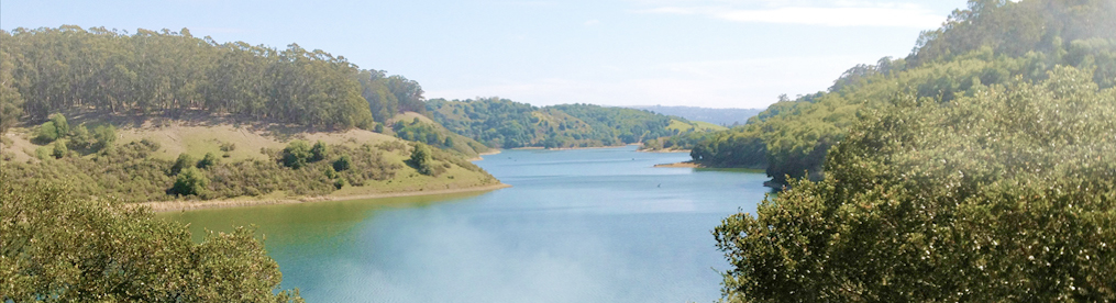
This was the Devil’s Day: We hiked the Ruisseau, Les Chutes, and Le Lac Du Diable. That would be the Devil’s Brook, Falls and Lakes for those of you who’s French isn’t as well spoken as mine. (Of course, my amphibian amis have been tutoring me these past few soirées.). ANYway, we had a grand day on the trails – starting out along the International Appalachian Trail. Off we went – following first the Ruisseau (Brook) Isabelle, then turning east towards the falls, and finally lake of the same general name. Passing through a wetland forest, the trail begins easily enough.

But mind though, as you pass this way, you must cross through an enchanted forest.

Quiet – you can sense the mystic creatures just out of sight, hear the rustle of leaves as they follow behind you…. Look quickly, and occasionally you catch a glimpse of them in the corner of your vision. This is the place where elven lights will surely lead you astray if you venture off the path on a moonless night. So tread lightly, and respect all who live here. Don’t anger the creatures of this forest!

Having passed through safely, we said adieu to Isabelle, crossed the Rousseau Diable, and began our trek upwards arriving at the first main attraction on this little jaunt: Les Chutes du Diable.

Though somewhat distant across the valley, they were still quite imposing- cutting through stone, falling many, many meters, cascading ever down – High and mighty these falls are – and beautiful to see. We dined here, a feast for the body and the eyes, even the ears as we listened to the many languages of fellow hikers, their accents playing counterpoint to the background roar of the water.

I think the TwoLeggs might have stayed here, had I not prodded them on. Alas, the next section of the trail is not quite so kind, as it begins to track upwards, gaining in altitude. Switchbacks and rocky climbs, a short scramble here and there, and the occasional illusion of flatter trail to come. It was along one of these brief tracks, where the Parc Service has places a protective boardwalk that we met a rather complacent, if not somewhat annoyed Madame avec siennes enfants:

This would be Madame, haughty and regal!

We stopped for a while to watch, listening to the little ones chatter without a care in the world, then mamma with her deeper cluck, speaking to us, telling us we are welcome to pass by, but mind our behavior, and leave the little ones be, lest we feel the wrath of her beak! We heeded the warning, gave a polite “Mais oui!” and continued on – everyone happy and content.

A few more switchbacks, and at last, a fork in the road, where other hikers stood contemplating their options. They went left – to the summit of Mont Olivine. We opted not to tag along, and instead forged our way on along a path slightly less traveled – to Lac du Diable. Now I’m not sure of the origin of the name, but this is a beautiful alpine lake – surrounded by mountains, the entire area carved by glaciers. Definitely a place where one should stop and enjoy all around you. So we did, and so should you, if your road leads here.

And with that, I bid you all a bon nuit. Until tomorrow!

Sugarloaf PP – Campbellton, NB

Once again, we arrived at our destination, only to be met with rain. And while the Road Toad would be quite content to sally forth, the TLs are not quite so enthusiastic when wet trails and muddy boots, and soaked clothing are the primary offerings of the day’s outing. Let that not worry you though. On our last day here, we did manage to get out for a few hours, and hike the trail that circumnavigates the base of the mountain, as well as take the half kilometer side trail to the summit.

The trail around the mountain base is one of multiuse – gravel, wide, with bikers, folks walking dogs, and fellow campers simply celebrating the sun. The summit trail, however, is far more interesting! Yes it’s another trek upwards. Steep enough in sections that the Park has thoughtfully added steps and a handrail:

And while it is only a half kilometer, there are few (“Were there any?” Minkie is asking me) spots to give those TL thighs a break. On the plus side, the path is generally well shaded, much to our delight. And about half way up, I met a toadal stranger, though to be fair, he wasn’t any stranger than many of my TL friends:

Meet Mon Ami, Pierre la SugarToad – fits in pretty well, I’d say

After a few minutes conversation in Francais, I learned he was from the Top of the Mountain, and had ventured down to see what was going on at see level. So I gave him the news from down below, and rushed onward to the summit. Here, there are great views of Campbellton, and the mouth of the Restigouche:

Campbellton, with Quebec Province across the river

And there also, flies the Canadian flag, beside a stone marker, dedicating this site to the three officers of the Royal Canadian Mounted Police who died in the line of duty one fateful day (June 4) in 2014. It is harsh reminder of all those who serve to maintain peace in our society – both at home and abroad:

And yes, when one goes up, one must also go down. This was yet another section where TLs have added assistance – both to make the way slightly easier and to make it slightly less treacherous. It’s easy to misstep on loose rocks and stones that offer little grip!

All in all, while Sugarloaf was mostly a stop to recharge, we came away pleasantly surprised. The campground is exceptionally clean and well run, fellow campers courteous and friendly, and more trails that we would like to check out. Perhaps in another year…..

“Won’t you come home, Mt Bailey?”

Have you ever walked a trail and found yourself wondering why you ever thought you might enjoy it? It is traveling steadily upwards, gaining altitude, and you are plodding on, hoping that the next curve will bring a little relief to those out of shape leg muscles and knees. It doesn’t. Even though it’s a forested trail, mostly shaded, this is summer, the humidity reminiscent of that in the lower latitudes. The sun, where it shines, is merciless.

And then, you take a look around. Here are sugar maples, old, magnificent. There are the white birches, reminding you of days when these trees served to fashion modes of travel. And now the scent of balsam fir – a smile, it’s Christmas in August. Ahead, a clearing, and overhead, the clouds race. The trees open up, granite outcroppings emerge, and below you see a lake, wide, lazy creeks and rivers where moose might take a swim. And suddenly you realize, those legs aren’t quite so tired, the heat not quite so oppressive – and yes, this is why you walk these trails.

Yes, Mount Bailey is rated “Strenuous” or “Difficult”, depending on who you talk to. So of course, the trail goes up and up some more – even if not as up as some of the trails we’ve done. Still, for a first workout, it fit the bill. And after a couple of hours upping on, as it were, we reached the summit, and just below, a picnic table overlooking the view above.

While the TLs snacked I brushed up on my French with this little fellow, who stopped by for a brief chat:

Mon ami, Jean Pierre Tamia

And because we didn’t see any moose I convinced Minkie to take my picture instead!

And that, my friends, pretty much says it all –

Our last day was spent with yet more rain, so we are off again, to Sugarloaf Provincial Park, where I hope to get these last few posts loaded. And perhaps, there, a little sun will shine again!!

Bon nuit!