The Highline

The Toad understands why this is one of the most popular hikes in the Park. It has views. It has more views. It has a reasonable difficulty level. And views.  And starts with a cliff walk. With views.   OK, so I’m going overboard with the view thing. But let me tell you, this is an incredibly stunning, over-the-top hike along open mountainside, up near the top – for some 8 miles or so before it begins a downhill trek for the final 4.   Much of the upper part has steep drop-offs on one side, so it is not a hike for those who get queasy with heights.  It is NOT difficult, just spooky!

The drive to the Trailhead is along Going to the Sun Road – spectacularly beautiful in itself.  It is also a spooky drive, preparing you for the hike to come.  The Trail begins up high in the Rockies, at Logan Pass, where a large parking lot awaits, along with a visitor center, and privies. Logan Pass is also one of the stops for the Park shuttle service, which you can take at the end of the trail to return you to your car.  You can see why this is a popular hike!  Park at one end, do the hike, and a free shuttle takes you back.  And believe me, after 12 miles, even a Toad really appreciates it!  Prepare well for this one:  the total elevation gain is 1300 feet, and total loss (you do most of this during the final 4.2 miles) of 3700 feet.   Good shoes, food, and lots of water are necessities.  And for the really masochistic amongst you, simply reverse the order – start below and hike up to Logan’s Pass!!!

On with it, now!  Leaving the Pass, the trail tracks along a cliff edge, with a cable to hold on to if you so desire. Minkie did.  At least a few times. After all, it’s a fairly narrow ledge in parts, and that drop is rather intimidatingly down. The cars below look awfully tiny….   Once off the ledge, the drops remain significant, though not so sheer:


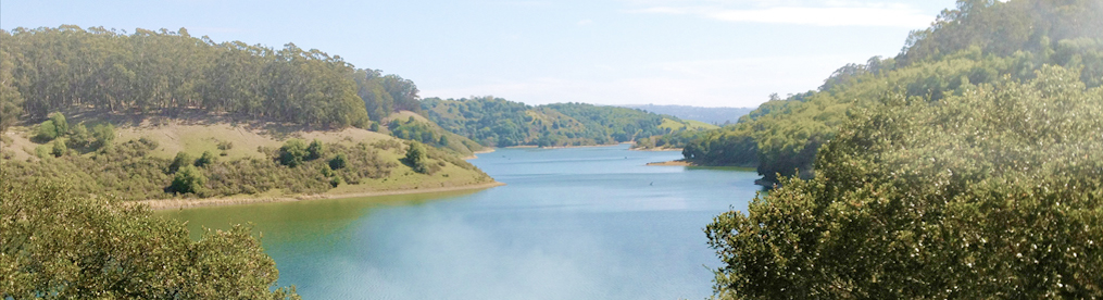
 You are still walking a narrow trail against a mountainside, but after a while, looking down (way down!) beside you ceases to have such an impact.  As you walk, you travel through alpine meadows, where wildflowers grow with raucous abandon.  Once in a great while, you are even treated to a fairly level (and usually short) section of trail:


There are creeks, waterfalls, avalanche chutes, wildflowers, snow fields (yes, a few remain in July!) and plenty of critters – more if you go early in the day, and are fortunate enough not to have too many parties just in front of or behind you.

Crossing one of several snowfields

And waterfalls….


As you travel, you realize that there is simply far too much for the eyes to take in.  Every corner, every turn brings another breathtaking view of mountain, snow, meadow, sky – pictures just cannot capture the experience!  

These flowers are a wildlife favorite – and grow in many, many spots along the way


After about 8 miles of scenery, you reach the historic Granite Park Chalet, and have traversed about two thirds of journey.  Here, folks can make reservations to stay the night, should they wish to hike in and out.  This is also an opportunity to a respite – take off your boots, eat some lunch, and take in some final scenery before you begin the 4 mile, downward travel to The Loop parking lot.  Should you wish, just before reaching the chalet, you might opt for another 1000 climb upwards over a mere .8 mile, to take in the Grinnel Glacier Overlook.  We didn’t – it adds another hour and half to the trek, and our day was already growing long.  

Heading down, snow, creeks, waterfalls, and meadows once again delight the senses. At one point, Minkie (leading the way) realized she wasn’t hearing Carlos behind us. She stopped, turned around, and sure enough, there was Carlos looking down at something on trail.  Unbeknownst to him, silently walking, bold as you please, came this critter:  


Totally unconcerned about his presence, she too, was headed down, munching on the delectable young growth along the trail side as she went. We took her picture, turned around, and left her to her own path.

And so the day comes to an end….


Yes indeed, this was a long one – and crowded, but well worth the effort and the constant presence of others.   It shows off Glacier in her finest – non stop views in the distance as well as immediately surrounding you.  If you come here, give this hike serious consideration!   

Glacier At Last!

Oh yes, the Toad’s been without either power or cell phone service for several weeks, with no way to share some of his recent adventures.  Boo Hiss, Toad!!  Well, we finally have both for a few days, and I’ll do my best to start the catching up process!

First up – GLACIER!!! The Toad waited far too long for this adventure, and it didn’t fail to deliver….  Glacier! Yes there are crowds! Yes, it is hot! Do we care? NO! Well, maybe a wee tiny bit – but not enough to spoil our fun!

So up and at it!  Our first adventure begins with the Apgar Trail – a less traveled trail, just inside the park. It begins innocently enough, in forest, that rather quickly, and unforgivingly, opens up – to new growth and little shade. This area was part of a major wildfire in 2003 that burnt thousands of acres here.  A few blackened trunks remain – skeletal reminders of the flames that burnt so fiercely.   This was a bad year for fires, burning around 139,000 acres (about 13% !!!) of the park.  


Apgar is a moderately difficult trail – gaining 1850 feet in elevation over about three and a half miles.  It is mostly a moderate incline, but the constant sun, and temperatures in the high 80’s quickly take their toll.  Be sure to bring lots of water!  

After about a mile, we saw a fellow messing with his pack about 50 yards ahead of us. “Did you see the bear?” he asked when we reached him. Well that got our attention. “Uh no….” “It was between where I am and I first saw you,” he went on. “He appeared on the trail, saw me and stopped.  So I stopped too.”  It was a young grizzly.
The fellow was pretty excited about it all, as I think my TwoLeggs would have been. He told them when he first saw it, he started to reach for his camera, then realized that his bear spray might be a wiser choice.  It was, however, in his pack.  It was about then that the bear got curious, and started towards him.  He countered with a “BOO!,” the bear took off, and then we showed up.  

We all had a good laugh, and on we went. Wildflowers lined the trail, along with huckleberry patches, a few young aspen, and of course, many new pines. Meadows are rapidly giving way to forest – and I suspect that in another 10 years, the views that are so prevalent along the trail will have largely disappeared. Finally, we reached the lookout tower, where there were already half a dozen folk, most of whom came on horseback. Now that’s just plain cheating!  The views were marvelous, though.  Lake McDonald with snow streaked mountains in the distance, the middle fork of the Flathead river, and even train tracks for Carlos (who has become quite enamored with the sound of train whistles in the distance).

Lake McDonald from the Apgar Lookout


After lunch, we headed back down. Surprisingly, we met quite a few parties on their way up – some seemingly ill prepared for the sun and heat that awaited them. Carlos and Minkie each polished off a liter of water, and lucky for me, they brought plenty for me too. A Toad likes his water!

Tomorrow I think we’re off for a bit longer trek – more then!

Mount Fernie Provincial Park

Yes, we had to bid Peter Lougheed a fond adieu, and work our way on to our last stop in Canada – crossing the Continental Divide again, leaving Alberta for our stay an Mount Fernie Provincial Park in British Columbia.  Once again, the drive rewarded us with non-stop beauty.  Here are the rolling foothills of the Rockies, rich farmlands where hay (alfalfa and Timothy), rapeseed (think Canola oil), and cattle are the primary crops.  Mile after mile (or kilometer after kilometer) of rich, open farmlands, interspersed with forest.  Not marked as a “scenic” route, my TLs were hard pressed to understand why!

Fernie is a smaller Provincial Park, in an area chock full of hiking trails. After settling in and chatting with a few local folk, we opted for a drive up the mountain, to a private lodge (good eats!) and lands both of which are thankfully open to the public.  Our trail of choice was the Tamarack Trail.  Up you go, up, up, and up some more. The trail snakes its way across Mount Fernie – through Tamarack and Larch forests, over scree, along ridge top, and up some more. 

All along the way, the trail opens up to reveal vistas of the valley below, and the mountains across. This is not an overly difficult hike, nor is it a difficult trail to follow – but it does require an effort! In some spots the trail narrows dramatically along mountain side, with steep drops – so mind your footing!   
Half way along is a scenic overlook – meaning there is a nice bench atop a rocky outcropping, for a rest and a picture or two.

On an outcropping, looking down on the lodge and lake…


The TLs tarried a bit here, just enjoying the afternoon. 

OK, I couldn’t resist a selfie!


Then off we went to explore – going ever up until reaching the end of the trail at the mountain saddle. The peak itself was another hours hike away, so we didn’t go that far, in spite of my urging. We ended the hike tired but satisfied with a magnificent return on effort.


And as it turned out, the TLs were wise to head back. Back at the trailhead, feeling well satisfied, we hopped in the truck, and started our 5 mile trip down the gravel road home – only to discover a leaking tire. Badly leaking to the tune of a snake hiss as the air rushed out! We made it home, but rather than a rest with an adult beverage, Carlos had to change a tire – which of course means finding all the accoutrements that one has never needed before! Out comes the owners manual, and sometime later, we all climbed wearily into bed, wondering if the puncture could be repaired.

Up the next morning, to the local tire repair folk, who fixed it (“Wasn’t sure we could, but we gave it a try and it’s a good patch. You’ll be fine.”). And so far, all is well!

Yes, Canada has been an adventure – from purchasing a new trailer and little malfunctions there, to explorations in the Canadian Rockies. Marshes and mountains, wetlands, bears, rainforest, ancient cedars and hemlocks, waterfalls, mosquitoes, raging rivers, lakes and cirques – wonderful provincial parks, national parks – we have thoroughly enjoyed visiting our neighbors to the north. In addition to the scenery, the people of Canada have been ever so gracious, welcoming these travelers from so far away. Thank you, Canada!!

Peter Lougheed’s Lake Rawson Hike

The Toad knows it’s been far too long since his last post, but as you may have imagined, our cell phone service has been negligible as we travel in Canada’s parks and now the mountains of Montana.  So, bear (not a grizzly, please!) with me as I slowly tell you about our wandering….

Our last hike in BC’s Peter Lougheed Provincial Park was a hike to be remembered, as every once in a great while, a day just turns out perfectly. Ours began ordinarily enough – I hopped outside for a few 6-8 legged morsels while Carlos and Minkie at their breakfast and packed lunches. Off we went to the Visitor’s center, to check for trail closures.  Sure enough, the trail we were contemplating was not recommended due to bear activity, so off we went – to see if Rawson Lake was as crowded as it had been over the Canada Day weekend.  Lucky for us, it didn’t appear too bad, so we opted to give it a try.

Rawson Lake won the toss. It is a beautiful hike – relatively short, easily completed in a few hours.  It begins as a leisurely stroll around the Upper Lake, crossing a bridge at the base of small waterfall that spills into it:


Shortly beyond this point the trail heads away and the first mile is mostly up a steep grade in the subalpine forest.  Switchback upon switchback, takes up climbing as you gain most of the 1050 feet total elevation in this section. The last third is far more sedate – gone is the huffing and puffing, and while you still go up, the incline is far more subtle.  Here the creek is loud as it bounds downward, hinting of the lake ahead. 


 And then, you see the break in the trees, and before you know it, you have walked into a field of scree.  Crossing this, the mountain cirque and Lake Rawson greet you.  


Not far ahead, the official trail ends, though hikers we met along the way spoke of hikes up to the ridge.

We opted to lunch on the rocks at the lake shore, taking in the scenery, watching fish jump, and listening to the wind howl as it raced through this tiny valley.  How is that water is so crystal clear? That snow still stands in the early summer? That mountain tops are so inhospitable, and a few hundred feet below, meadows of wildflower erupt in raucous color?

Carlos and Minkie took their time over lunch, and once finished, we reluctantly bid farewell to the lake.  Needless to say, the going was a little quicker and easier than the coming.  

A fine sunny day such as this, filled with a decent, even if not rigorous hike, especially on a final day in Peter Lougheed certainly deserves a fitting end.  So, of course we stopped at the trading post and each had a huge “single” dip ice cream cone.  These are not tiny singles, either!!   Rich and packed with flavor, the cones made my TL’s about as happy as a couple of TLs can be.  

Back at camp, we packed what we could, to get a quick start on the next day’s longer day to Mt. Fernie.  More on that in the next post!

Peter L and the Black Prince Cirque

With each morning awakening, the Toad looks himself in the mirror and says, “Toad, how could it get any better??” He keeps this thought to himself, as he watches his TwoLeggs enjoying morning coffee, and preparing for the day. Breakfast eaten, lunch packed, and me, the Toad, comfortably ensconced in his travel sack with Minkie, and off we go. Today we took in the Black Prince Cirque. It is a relatively shortish hike, though the first section is all about elevation gain. Like many of the hikes here, though, this is part old logging road – wide, gravelly, and up, up, up.   

Then the going is less about up. The trail narrows to a forest trail.   


Here and there it only moss that covers the ground beneath the conifers.  The air smells of fir, and we think perhaps we have once again, found ourselves transported to some other world. The forest thickens. We cross streams, the path still gaining in elevation, but ever so gently.  

Suddenly, there is the Cirque.    Here, a lake appears – almost magically, as it is an intermittent lake.  With unusually heavy rains of this year, it stands in full glory.  Crystal waters reflect the cirque above. Snow still covers the deeper crevices, less and less evident with each day’s sun.  We are gifted with a scene that simply overwhelms.


After spending some time here, basking in the colors, scents and sounds of these mountains we turn back towards camp – where hot showers and Carlos’ BBQ chicken await.  No complaints.

Peter Lougheed Provincial Park

How does a mere Toad describe the grandeur of the Canadian Rockies? Not very well! Still, I have to try, so I called on Minkie for a little help…. Our travel here, crossing the Continental Divide, was breathtaking, to say the least. We have come to realize that the scale of these great mountains is just nigh on to impossible to take in. Throughout the drive here, and daily, as we walk trails, hike to cirques, lakes, alpine meadows, and streams – we are constantly reminded of how overwhelming the scenery is. None stop beauty. Massive mountains, carved by glaciers, with wetlands (fens) slowly filling where recession is complete. Lodgepole pine and white spruce. Grizzlies, moose, wolves, hawks, eagles, marmots, loons – and all manner of countless other creatures call this area home. We are but visitors, and tread softly lest we destroy the very things we wish to see.

A couple of Bighorn ewes and chilluns…..

Peter Lougheed is a provincial park, in the heart of the Rockies, surrounded by protected lands- be they park, refuges, wilderness areas, or recreational day use. The Park itself sits between two Ranges – the Opal Range to the east, and the Spray Mountains to the west.  Southeast are the Elk Mountains. There are miles of trails here – many are multi-use: Biking/hiking, horse/bike/hike, barrier free trails – quite a network taking you to multiple campgrounds within the park, as well as many scenic spots. Indeed, there are also plenty of hiking trails too – all are well maintained, though we did find that signage is often lacking. No blazes to identify intersecting trails, some of which are neither shown on maps handed out by staff, nor described in the park literature. So be careful, and mind your turns!!   
Our favorite hike so far has been to Ptarmigan Cirque – an area carved by glacier, that is as raw and harsh an environment as one might imagine. The trail is a steep ascent through forest dominated by lodgepole pine and spruce. You work your way from switchback to switchback, until you suddenly emerge in an alpine meadow, above which is a massive rock amphitheater. Nanatuk – the name for those Rocky Mountain tops that were never covered by glacier – where no soil forms, no trees take root, and few animals live. Barren rock – where ice, wind, sun and rain slowly work their magic, as the small shards and pebbles fall below, or more dramatic rockslides and avalanches gather detritus and take it ever downward to eventually become soil for the life below.

Ptarmigan Cirque


The trail is not difficult, steadily working upward, but there are no difficult passes, and the loop is easily completed in several hours, taking time to enjoy the scenery!

And lest we all get too dramatic, this little fella should remind us that we are but a trespasser in this land!

A silver back marmot – “Excuse me, what are YOU doing here?!”


Another longer trek took us up to Elk Pass, through an evergreen forest. Rain has been less than the lodgepole desire – look carefully, and there are signs of “rust” – needles browned from lack of moisture. The trees will recover, though they are a bit more susceptible to other stressors. This is no land for sissies! 

A look at the Opal Range from a spot near the Elk Pass Trailhead


 This trail is one shared by hikers and those on bikes, though we saw only two such intrepid souls. It is a steady climb for a mile or so, along a broad, well maintained gravel path. The trail crosses a stream, where bikes go left, hikers to the right. Up along Fox Creek, through wetlands and more forest, and then to the Pass. Here you are meet the border between Alberta and British Columbia, and yes, the trail goes on.   The beauty of Elk Pass – the vista looking to the Elk Mountains – is somewhat marred by the presence of a power line, but such is the mark of progress, and a necessity to the people who live in the surrounding private lands.  It was also a great place for the Toad to snack – yep, my favorite mosquitoes were in abundance!  

Ah, but one cannot snack forever, so the TLs and I headed for home; they opted for hot showers (not my cup of pond water), and then for a few adult beverages for the TLs, and dinner;  BBQ for Carlos and Minkie, a few more mosquitoes and night flies for me. We are a contented bunch, to say the least!

Red streak at Radium Hot Springs: how cool is that?!

Yes, I know, the Toad has been silent for far too long! Apologies to all, but such is the fate, when a mere amphibian must depend on a TL convention called cell phone service! Ribbit harumph. We have a night, maybe two, so I’ll do what I can to catch up you up on our Canadian adventures!

First – we have resolved most the Toad’s Abode’s issues. Minor calumping and thrumming from the water pump, but we think it is but an adjustment that Carlos will continue to work with. Most of all, our hats are off to the good folks at Escape, who have been great to work with!   

Leaving Chilliwack, we headed back to Blanket Creek for a peaceful night, staying this time in the newer section of the park. Here too, sites are incredibly well separated, and provide ample privacy for those who wish to chill, and turn in early. Not that the Toad would – no sirreee. While Carlos and Minkie snoozed, I feasted!   

The following morning we were off again, to spend the remaining two nights of our reservation at the Redstreak Campground in Kootenay National Park. The drive was nothing short of awesome. Nearly every mile brought mountain and forest and lakes into view. As we’ve come to appreciate, the road follows river valleys, sharing space with train tracks, so once again – water and tunnels, against a backdrop of rocky, oops Rocky Mountains.   

Mountains are steep, heavily forested where it seems impossible for a tree to grow. Bare cliff faces and rock slides sound out as ock marks harsh reds, greys, and blacks etched against the carpet of green. Snow caps the highest peaks, and every direction you turn, the grandeur passing by takes your breath away. Such was the first half of our journey on our way to Kootenay National Park. 

The Purcells!


Turning south at the town of Golden, the second half of the drive tracks along the Columbia River and its extensive system of wetlands that comprise this massive valley between the Rockies on the east side and the Purcell Range on the west. Looking below, Minkie spotted a pair of trumpeter swans swimming lazily, seeming to enjoy the midday’s warming temperatures – the elegant curve of their long necks a snowy contrast to sapphire blue water. To the east, the Rockies serve as a backdrop, the Purcells on the west, with river spreading in the wide valley between. Here we passed cottages that hinted of fairy tales. Hansel and Gretel would have felt quite at home here. Each turn of the road added yet another variation on the theme – farmers mowing hay fields here, baling hay there, cattle grazing, a stone fence, open meadows of wildflowers, thick evergreen forest – mother nature’s symphony in full chorus.   

Our arrival at Redstreak brought us a visit by a hen turkey and her half dozen or so young. They wouldn’t quite sit for a family portrait, though Minkie did capture mamma keeping a keen eye on things. 

And turklet scampering by the neighbor’s trailer!


 It was especially rewarding to listen to her talk to her brood. When Minkie first approached, mamma stood still, assessing the intent of this TwoLegg. I assured her there was no danger, and soon we heard a low coo, and one by one the youngster rose from grasses, and all started grazing. We watched them again later, when a murder of crows flew in to harass the family – mamma was NOT pleased.

We also had a ground squirrel colony on the hillside behind us, who were quick to sound the alarm when danger approached. 


They set up quite a stir when hawkbird came by for a brief visit!   

Regrettably, real hikes were not to be, but we did take in a nice 3 mile walk to the famous hot springs and back. The trail is nicely maintained, mostly forested, winding through a few wildflower meadows, and providing occasional peeks at the mountains. 


Next up, Peter Lougheed!