Chemin-A-Haut: Bastrop, LA

From a Road Toad’s point of view, this was a nice park – lots of mosquitoes (especially nice during happy hour!), a full day of rain, a small lake (which my TLs walked around, but didn’t let me go in…..), a few relatively short nature trails, and very quiet with only one other pair of two-leggs camping.  Carlos and Minkie didn’t seem to take to it quite as much as I did, but then, they are two-leggs, and seldom appreciate some of these finer things in a road toad’s life.   From the TLs point of view, Minkie describes Chemin-A-Haut as an interesting park with a lot more amenities than many we’ve visited.  She says it has a touch of the ‘resort’ to it – with an amphitheater, nature center, meeting hall, volleyball court, pool/bathhouse, pavilions, two playgrounds, and cabins.   It also has a group campsite as well as an area that accommodates horses.   And while the bath facilities were “a bit tired” they were clean – and that’s the most important thing to Minkie.

Our drive from Caprock was pleasant as we watched the topography and vegetation become more akin to the southern part of the country where we hail from.  We didn’t arrive until late afternoon, when Carlos came across one of the first conundrums of its kind that he’s encountered – the electrical supply was reversed in its polarity.  Checking the Toadal Home’s manual (before we hooked up) he discovered it would damage the converter (whatever that is).  Well that wasn’t a happy dance moment.  Off he and Minkie went checking other sites, while I went to work on the mosquito population.  There weren’t a whole lot (of sites – plenty of ‘skeeters), and they discovered this problem wasn’t unique to our site.  As they walked the loop they also discovered some sites with apparent drainage problems (and rain was predicted all night and the next day); others that presented leveling problems; and a few with sizable holes in the pavement just about where the trailer wheels would need to be….  Don’t get me wrong – there were plenty of sites that would work, but my TLs can be picky sometimes, and this was about to become one of them.  Lucky for me, better sense prevailed (that’s TL talk for happy hour calling), so they just moved over a site and started the leveling process.  With uneven asphault, it was a bit more difficult than they expected, but eventually they got it worked out, and then sat back for an adult beverage while I digested my earlier mosquito banquet.

DSC02454 (800x600)

The Toad Home – oops, TLs’ Casita

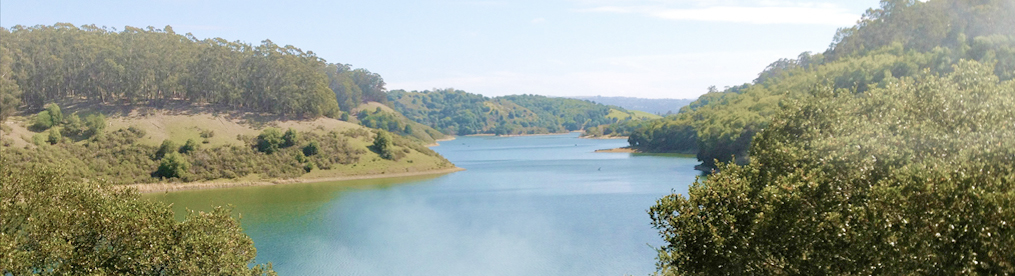
Oh the trials and tribulations we must suffer.  The next day it rained all day, just as predicted.  After some discussion, a couple rounds of cribbage, and a nap or two, we decided that we’d walk the trails the next day.  We discovered they were well maintained for the most part, though one section was a bit tricky due to logging and bush hogging.  One of the park rangers told Minkie they were removing old and dying trees, but there was a lot more down than just that.  Anyway, the trail was very pretty along the bank of the Big Slough Lake, which is really a little slough lake.  It appears mostly shallow, and there’s no swimming.  I think there might be gators there, but Minkie was careful not to discuss it in front of me.  She knows that I’m no more fond of gators than I am snakes!  Anyway, the lady that talked to Carlos told him you could canoe from the lake into Bayou Bartholomew – but for the life of us, we couldn’t see how that was possible.  None of the maps showed any connection between them…

DSC02459 (800x600)

Big Slough Lake – view from the canoe launch

DSC02464 (800x600)

Walking along the western shore


Well, we weren’t able to find much else in the area in the way of hiking, and because this was during the now famous federal shutdown (what is it with your Two-Leggs Congress?!! ) even the wildlife refuge that might have been fun to  wasn’t an option.  So, we decided to leave a day early and head further east to Mississippi, where I was thwarted once again from taking a little dip in the big Muddy.

Next up:  The SECOND BIGGEST LOBLOLLY PINE IN MISSISSIPPI, brought to you by Smuchi, the American Road Toad, and his best buddy, Carlos!


Haynes Ridge and the South Prong Trails

As I said earlier, the Two-Leggs just had to repeat the Haynes Ridge Trail – so sure enough, that’s what we did.  This time, we opted to go in the opposite direction, going up the section that was such a jolly good scramble coming down.  It was also a scratch and grab going up.  Once again, though, Carlos and Minkie did just fine – arriving at the Haynes Overlook only slightly out of breath, all limbs intact, no scratches or injuries.  The views were as good as before, and the trail along the ridge just as beautiful.

DSC02385 (800x600)

Once at the junction they opted to stop for lunch, taking advantage of the lone bench, sunshine, and a little less wind.  The sun played hide and seek with the clouds as my TLs downed their sandwiches, drinks, apples, granola bars and crackers with gusto.  Honestly, why they don’t appreciate a few good flies and mosquitoes is beyond me, but any time one of MY favorites comes along they start swatting, with little regard for me, the Road Toad.  I guess that just my lot in life….

After the midday feast, we took off along the South Prong Trail – also marked “challenging”.  It too showed less travel than those allowing multi-use.  Again, the views were notable – and again we all commented on how much greener this land is.  Not that it would seem so if you hadn’t just spent so much time in the semi-desert canyon country!  It is still plenty dry, and the vegetation stunted by lower rainfall.  On all of these trails there were plenty of fall wildflowers – daisies or sunflowers in whites and yellows, asters in purple, and other flora we couldn’t identify.

DSC02393 (800x600)

The South Prong winds its way slowly down along the canyon wall, offering  shorter steep sections as you work your way around each of the fingers that jut out into the valley.  It was towards the end of the downward section that Minkie took a spill – one her two-leggs slipping on loose rock.  She fell backwards, bending that sore knee of hers in a way that would have been better not to.  But once again, luck was with us – no significant damage was done, though she walked with a bit of gimp the final mile or so.  Too bad you two-leggs don’t have the gripping foot pads of a Road Toad.  This sort of thing just wouldn’t happen!

Anyway, it was a little slower journey back, but we were just about at the river bed when this happened, so we didn’t have to negotiate any really tough terrain along the way.  And even with the mishap, both Carlos and Minkie considered this the best of the hikes in Caprock – one they’d gladly do again.

DSC02285 (800x600)

Saying goodnight and so long to the bison and black-tails, we headed off the next day for Louisianna.  Crawfish gumbo, bayous, and zydeco – HERE WE COME!  Laissez le bon Toad rouler!  Yee Haw!!!

DSC02400 (800x600)

Hiking in Caprock

We took two really nice hikes in the western side of Caprock Canyons – here the walls are a little higher, and the trails have a few good sections of scrambling to adding to the interest in both footing and scenery.  My TLs seem to enjoy this sort of thing, and as you’ve figured out, since I’m along for the hop, I’ve come to appreciate it as well.

DSC02316 (800x600)

The trail begins….

Our first venture was up the Canyon Loop Trail (1.3 miles or so) to the North Prong Trail (another 2 miles), back along Haynes Ridge (2.3 m), and another .5 mile along the Canyon Loop back to the Trailhead.  These are all marked “moderate” except for Haynes Ridge which is considered “challenging”.   I should point out that the trails are all well marked, and for the most part, quite reasonable for the average hiker in good condition.  The first mile or so of this loop was relatively flat – primarily along the floor of the canyon.  It’s a wide trail, and would appear to accommodate the casual stroll, but be forewarned that there are plenty of spots where the ground is loose rock and the way riven with water-erosion crevices just waiting for a misstep to turn an ankle.  All but the Haynes Ridge Trail allow bicycles and horses, and while we saw evidence of earlier passage, we met none during our ventures out.

Once you enter the North Prong Section, things start to get a bit interesting.  The walls of the canyon slowly grow closer, and here and there you see sandstone spines, jutting out of the ground below, reaching skyward.   There’s even a hoodoo – The “Last Dance” – to catch the eye.  As you reach then of this trail you come upon the “Fern Cave” – which isn’t really a cave, but an outcropping which forms a roof, from which ferns hang.  This served as our lunch spot, though the cave itself offered no good table, so we opted for some boulders close by, looking down a dry creek bed.  Not a bad spot to take a breather!

DSC02326 (800x601)

The Last Dance

DSC02333 (600x800)

Lunch break outside the Fern Cave

Then the fun begins.  It’s a bit of a scramble up to the junction with Haynes Ridge (and the South Prong Trail) – nothing too intimidating, but definitely adding interest.   It’s also evident that this last little bit of the North Prong is only hiked – bikes and horses would likely suffer in any attempt up or down.   At the actual junction of trails, Haynes Ridge appears much less traveled than either the North or South Prong, though it’s hard to understand why.   The way up and down both involve scrambles, but they are well worth the effort for the views it provides.  Along the Ridge are wonderful view of the canyons on either side.  It is also the highest point of in the park, so when the weather is clear, you can see well beyond the park across the valleys for miles beyond.  Vegetation along the ridge changes, taking you at times into a lovely dense juniper grove, at times into more open sections of scrub oak, prickly cactus, grasses, and those dang thorn bushes that Minkie never took a cotton to.

DSC02348 (800x600)

The northern canyon from Haynes Ridge…

DSC02343 (800x599)

…and the southern canyon


As is almost always the case, what goes up, often must come down.  And yes, you do have to come down off the ridge to get back to camp.  And the way down was a hoot and a half.  It has wonderful section where you realize the way forward is really right down what looks to be a dried creek bed – loose rock and boulders.  Use hands, feet, and anything else you can think of to negotiate the way safely.  It isn’t overly difficult, but does require that you move thoughtfully!

Back at camp, it was time for happy hour and another lazy evening, once again reflecting on all that nature has to offer, and thankful that it is preserved for us to enjoy!   Next Hike:  Canyon Loop, Take Two:  Haynes Ridge and the South Prong Trails

DSC02315 (800x600)

Daisies – everywhere


The Road to Caprock Canyons

All good things come to and end, or so they say, and it was certainly the case with our hiking in Utah and Colorado.  Leaving Ridgway and the Rockies we drove and east and south, watching the scenery gradually change from mountain and forest back to the more arid climate of the high plateau  – with its mesas, buttes, canyons, and occasional spire or hoodoo.  We opted for an overnight stay in Trinidad State Park – which sits on a low ridge overlooking Lake Trinidad.

DSC02225 (800x585)

View from our camp chairs, overlooking Lake Trinidad

It is a smaller park, featuring water activities, and a new camp services building that is probably the nicest and best laid out that we’ve been to.  Minkie particularly liked the showers – which offered both a private dressing area outside each shower, and a long counter top complete with mirror and sinks apart from those associated with the toilets.   Staff kept the entire facility clean, and their attention to detail was apparent everywhere.  The laundry facility housed multiple washers and dryers, tables for folding clothes, and benches/tables to sit at while waiting for machines to finish.  Not a “destination point” for us, but a very nice stop over!

The second day took us further south, traveling a short while in New Mexico before entering Texas.  Once again, the scenery kept my Two-Leggs interested, as the mesas and buttes DSC02229 (800x369)gave way to rolling hills and grasslands, then prairie, and back again.  Agriculture was dominant along these roads – huge cattle ranches were interspersed with hay fields, sorghum, and the odd buffalo ranch, sunflower field and even a pumpkin patch.

DSC02243 (800x592)

Windmills on the flatlands

DSC02248 (800x600)

Cattle and hay….


We also saw pronghorn both days, and Minkie became fixated on trying to get a picture.  As you can see, she was marginally successful.

DSC02233 (800x475)

Car window photography at its finest….(or is it “finished”?)

And finally, we made our destination.  Ah, Caprock Canyons!  This state park is a really neat park, and has earned its bragging rights.   It is home to the official Texas Bison Herd – a herd of about 100 head which are directly descended from the Southern Plains bison, and genetically isolated from others.  Because of this the herd is one of the five foundation herds that are responsible for most of the bison reared commercially today.  These are big ladies and gentlemen – weighing up to a ton, and reaching up to six feet at their “hump”.  They are wild, roaming freely in the prairie that forms the entrance to the park.  Visitors are cautioned about approaching them – they are capable of speeds up to 30 mph, so you don’t want to try to out run them!  Yesirree – these are magnificent creatures – almost as fascinating as a Road Toad, and a whole lot hairier.

DSC02368 (800x600)

Takin’ it easy, as only a bison can

DSC02371 (800x600)

Tres Amigos


As for the campground, it is relatively small – some 30 sites or so, with most having reasonable separation from their neighbors.  Because it was crowded when we first arrived, we opted to move our second night (to #20), and scored a very private little spot, the best in the campground, as far as Minkie was concerned!

Besides good hiking, the park has another fun feature – a colony of black-tailed prairie dogs that lives right outside the bathhouse.  And what a hoot they are!  Minkie did manage a picture or two, but the only way to truly appreciate these little guys is to sit for a while and watch them.  They chatter and whistle, chirp, and thump – all the while keeping a wary eye on any two-leggs in the vicinity.  Get too close and the sentries stand up, call out a warning, and the rest dive for the burrows.  Stay still, and heads will start to pop back up, and slowly out they’ll come and resume foraging, playing, or just hanging out.  Wonderful entertainment!

DSC02378 (800x554)

Tres Amigos too

DSC02281 (800x549)

Dos amigos: Sentry duty


Now before I go into much about the hiking, you got to understand that these canyons are a bit different than those of Utah.  Here the walls are not as high, the valley seems wider, and the vegetation is definitely more dense.   We didn’t see slots in this area, but the effects of wind and water are just as prominent.  Out first trail was to be a short afternoon walk along the Holmes Creek Canyon rim, and while the trails are generally well marked, we missed the “spur” that was to form the loop back.  Instead of a two miler, we wound up walking the full 3 miles before noting our oversight (which was cleverly made evident by a sign saying “Wildhorse Trail”).   No problem for my Two-Leggs, that is, until Minkie stepped on a thorn (she called it the devil’s stake) that went all the way through the sole of her running shoes (last time she’ll hike in those!) into her little foot pad.  Luckily it hurt more than harmed, and nothing more came of it.

DSC02267 (800x600)

Holmes Creek Canyon

Once back in the campsite, it was time for the adult beverage of choice, a bit of prairie dog entertainment, and a lovely sunset.  Evening winds turned out to be a constant feature of the park, strong enough to keep the flies away (for the most part, anyway) and one night, strong enough to rock our Toad House.  Carlos and Minkie would have preferred it just a a bit calmer –  as it was, we didn’t get to have a campfire, but then, sometimes that’s just the way things roll.

DSC02288 (800x600)

Caprock Sunset

Next Post:  Hiking the western canyons

Ice Lake

Of all the mountain hikes we’ve taken, this is right at the top.  Pokey and Gumby had told my Two-Leggs what a fabulously special place Ice Lake is – and let me tell you, it lived up to our expectations and then some. The trailhead is located just outside of Silverton, so we had a bit of a drive through the mountains to get there.  The drive didn’t disappoint, either!  This area of Colorado is about as scenic a mountainous region can be – with fall colors starting to pop out amidst evergreens, white snow capping the tops and sliding down the sides of mountains; and of course, there is that Colorado blue sky.

DSC02154 (800x600)

Along the road to Silverton

The trail itself is superbly beautiful, and yes, difficult, but your work is consistently rewarded all along the way.  By the way, “the way” is generally straight up.  Think switchbacks, more switchbacks, and then some more.  We knew it is rated by some as difficult, but my Two-leggs were undaunted, so off we went.

DSC02209 (800x600)

Aspen gold for a spark of color

DSC02160 (800x600)

Headed for those mountain tops


Up we went.  Minkie led the way, and for a while, kept up a good pace.  She intended to count switchbacks, but lost track somewhere around 15 or so.  Luckily,the footing is generally good, though there are a few sections where you have to watch where you step, lest you slip on loose rocks or slick soil.  (Generally speaking, this is not a good thing to do.)   Periodically, the trail opens up and gives you a look at the valleys below, or down a meadow, or across deep ravines to rockfall, or over to a waterfall.  Color was everywhere.

DSC02169 (800x600)

Getting higher, but this isn’t close to the destination!

The only significant respite in this trek comes with a drop-dead gorgeous alpine meadow above Little Ice Lake.  Unfortunately, every time you think it will appear, the trail just turns upward. Finally, as Minkie was growing more certain that any lake was a part of mountain mythology – there it was – Little Ice Lake!  It sits below you at your end of the meadow, and is fed by at least three named creeks, which erupt into waterfalls out of the surrounding mountain ridges and run into and through the fields of grasses, wildflowers, boulders and shrub on their way to the lake.

DSC02173 (800x600)

Little Ice Lake. More meadows to the left, and more trailing up to come

I thought that Carlos and Minkie would stop here for lunch, and they did consider it, but they also kept looking up, to see where the trail might go from this point.  (I could have told them if only they’d listened – “Up, you two-legged fools!”)  But of course, they had to check out the waterfalls, so on we went.  Lest you think this is a time for lolly-gagging, let me tell you that it is out of the meadow where the punishment really starts to kick in. Here, above treeline, you meet the a few stretches that just about take your breath away with the effort of going up.

And at each new switchback, each new view of yet another possible saddle, Carlos and Minkie would say to each other – “We gotta be close!”  And we were, sort of.  Anyway, the last killer stretch up finally proved itself to be the point they were looking for.  We actually reached that darn saddle, and ahead (but only slightly more upward) lay a field of snow.

DSC02193 (800x600) (800x600)

The last vicious climb, and your at THE saddle

A little ways further along, Ice Lake jumped into view – in all its splendorous blue.  This is a glacial lake, and its blue is bluer than blue can be imagined for water.  Out came additional clothing from the packs, and down to the lakeside we all trekked.   We ate on rocks, admiring the view, and reveling in yet another slice of nature’s great glory.  Few words were spoken as for whatever reason, we all felt a touch of magic in the air.

DSC02187 (800x600)

Ice Lake, and the magic of blue

The return trip was no less beautiful, and a WHOLE lot easier!  Though downhill trails can be hard on the knees, I didn’t hear a word of complaint from either of my Two-Leggs.   Down we went, with grins on our faces, and words of encouragement for the few folks we met who were on their way up.  This was our last Colorado hike of the trip, and definitely, though we didn’t know it before hand, the best had been saved for last.

Coming up:   Caprock Canyons

Blue Lake

Ridgway is near towns like Ouray, Telluride, and Aspen.  Places known for great skiing, and of course, in warmer months, for great hiking.  As I mentioned in the last post, we got a great surprise from Gumby and Pokey who said they’d be in the area, and this was a trail they were interested in hiking – if we were so inclined to join them.  And of course, we were.  They arrived on a Saturday morning, and we planned for a good day hike and a celebratory dinner in town.  This time, events went according to plan!

Cooler days and nights in Ridgway meant we abandoned the shorts and T-shirts of Utah for jeans, long johns, and more layers.  Good thing too – my two-leggs found themselves on snow covered trails in no time.

DSC02123 (800x600)

On the way to the trail head – a hint of trails to come

I watched my brother Smoochie leading our pack, as up and up we went.  Gumby and Pokey brought their Bodie the Snow Dog – who reminded us all of how joyful it is to encounter newly created Colorado Sandstone.  The higher we went, the more layers came off the two-leggs, and every now and again my Minkie would whimper “Are we there yet?”  Of course, the answer was usually no.  But let me tell you, as we DID get arrive, all thoughts of mutiny were abandoned.

DSC02093 (800x600)

Arriving at Blue Lake

DSC02116 (800x600)

Colorado Sandstone and evergreens – we couldn’t ask for more


When walking through forest, you often don’t have open vistas to mark your progress.  Nonetheless, every now and again we’d spy the mountain tops peeking through pine, fir and aspen as we wound our way further up and up towards Blue Lake.  And then, there we were!

We had the privilege to visit yet another gorgeous alpine lake surrounded by mountains towering above, this time, with the added pleasure of the company of our Colorado companions.  We celebrated with Gumby’s wonderful chicken curry sandwiches, and while Pokey pushed a little further onwards and upwards, the rest of us rested knees, hips, minds and souls – and just reveled in the beauty around us.

DSC02099 (800x547)

Smoochie, Pokey, Gumby, and Smuchi

DSC02108 (800x600)

Bodie, Wonder Dog Extraordinaire


If you decide to hike this one, know that the trail isn’t particularly difficult – though hiking in slushy snow made for some interesting two-legg maneuvers both coming and going.  It does gain in altitude, but not punishingly so.  It is mainly in forest, until you get to the lake, and the trail is easy to follow (assuming of course, it’s not your first visit AND you’re not the first one over newly fallen snow), and  It also appears to be a hike that would be equally beautiful anytime of year.

Next up:  Ice Lake

Ridgway State Park – Ridgway, CO

After two days of scenic drives, we reached our next destination – Ridgway, CO.  It took us two days to get here, in part because we try to limit towing time to 6 hours.  When you add in stops for lunch, gas, and possibly groceries or scenic overlooks, it can be a very long day.  And this is vacation, after all – at least that’s what my Two-Leggs claim.  No worries for me, I’m just along for the hop and fun.  Anyway, the days were both bursting with more beautiful scenery.   Along the way we stopped at Devil’s Canyon, a national forest campground that was surprisingly quiet for being located along a fairly busy highway.   It was also along this road we drove through a section of road that was narrowed to one lane – the other had collapsed, having been undercut by flood waters earlier.  The creek was still running strong – with muddy water the consistency of melted chocolate.   Minkie was fascinated – the creek didn’t splash like others do – in spite of the fast moving water.

DSC01977 (800x332)

Muddy Waters – Minkie’s melted chocolate

In juxtaposition to this image, we then came upon what remains of the Lake Powell reservoir.  It is just about dry, reverting to the empty canyon with a river coursing through it, before the dam was built.  It is a stark reminder of ongoing drought in this part of the country….

DSC01982 (800x600)

The bright spot just left of center is the river – that area would have all been water…..

From Devils Canyon we traveled north, leaving the the high desert land with its fantastic formations …

DSC01996 (800x600)

DSC02009 (800x600)

for the forests and snow in the Rocky Mountains.


Ridgway State Park is a huge park located just off Hwy 550.  Along with three campgrounds (one with full hookups) it has a Marina, and offers a swimming and picnic day use area, each set apart from the other.  We opted for the Elk Ridge campground, with electricity and shared water (that means a single spigot that serves multiple sites – fill buckets, but no hose connection allowed).  As the name implies, it sits high on a ridge, and offers views of the water below or the mountains off in the distance.

While staying here, we took several hikes and drives, taking in the change in scenery including one drive along Last Dollar Road, described as one of the most beautiful (and a bit tricky, given its need for a 4WD vehicle) in CO.  Leaves were beginning to change, particularly at the higher altitudes, and snow from the recent rains added icing to the mountain tops.  (Colorado’s white sandstone :))  This and a walk along one the parks lake trails made for an easy, enjoyable day of R&R for my two-leggs.

DSC02009 (800x600)

Ranch lands and mountains…

DSC02027 (800x579)

Driving through a stand of aspens


DSC02034 (800x600)

Tell me this ain’t pretty

DSC02043 (800x600)

A hint of color starts to show


DSC02063 (800x600)

And if Carlos will only get this little spread for Minkie….

DSC02076 (800x600)

… she’ll do the Magpie Strut


Bryce Canyon National Park

Bryce is but a short distance from Kodachrome so the TL’s and I decided we should pay it a visit, and see what the fuss is all about.  First, it is a larger, busier park.  However, we once we got a we bit down a trail,  we realized it  is well worth putting up with the busloads of tourists and taking the time to see.  Along with Capital Reef, it is probably the most majestic part of Utah that we’ve seen.  This is a canyon’s canyon – with formations more alluring, cliffs higher, and the floor far, far deeper than anywhere else we’ve visited.  Like at Kodachrome, the colors are rich – and everywhere you turn, you are tempted to take yet another picture to try to capture the memory of this aspect of nature’s grandeur.

DSC01776 (800x600)

A first look into Bryce Canyon – and beyond

As was the case with during much of our time in September, we were not able to take the hike we had hoped to, due to flooding.  (It still seems incredible to think of floods in a desert, but this was a bumper year for them here!)  Rather than hike the very popular Peekaboo Trail, which was closed, my Two-Leggs and I took off for the Hat Shop, following the “Under the Rim Trail” out of Bryce Point.

 Marked as one of the more difficult and less traveled trails, it is has sections that are steep and require good footwear, and because it starts off downward into the canyon, the return is mostly uphill.  Shades of the Black Canyon of Gunnison hikes from several years ago!  Minkie and Carlos were not deterred in anyway though, so off we went.

We didn’t get very far before Minkie started taking pictures.  It seemed like there was something she wanted to capture at every corner or switchback.  Of course, when you look at some of them, you can understand why.  Hoodoos, fins, spires of fantastic shapes, sizes, and colors seemed to pop up everywhere.

DSC01778 (800x600)

The trail begins

DSC01787

And the views just get better


Eventually, we even made it to the Hat Shop, where spires rise from below,with huge boulders atop them.   Now Minkie tried really hard to get good pictures, but it’s pretty tough.   I tried giving her tips, suggesting different angles, closer views or fooling with some of the buttons on the camera, but she’s just not that accomplished yet, and really doesn’t listen as much as she might to the wisdom of the Toad.   Although she might have done better, we’re posting these so you can see a little bit exactly what the Hat Shop is.   Remember, these are really TALL, SKINNY spires wearing VERY BIG boulder hats.

DSC01801 (800x600)

A close up of some of the hats


DSC01812 (800x600)

Boulder hats, aspiring to greater heights than their neighbors

DSC01802 (800x600)

Another view, in profile


After eating lunch admiring the hats, we headed back – to make sure we’d have time to take the drive out to the end of the park.  And what a drive it is!  The road follows the rim of the plateau with multiple parking stops along the way to take in the magic of Bryce Canyon.  Because of the many tourists, we weren’t able to spend a lot of time at any one spot, but we got a full appreciation of why this park attracts so many visitors from this country and around the world.  It is a world class wonder!

DSC01833 (800x600)

Hoodoo you think yer foolin’?


DSC01854 (800x720)

Natural Bridge

DSC01848 (800x600)

The King,surveying his domain


Should you find yourself in the area, get your head ready for crowds, then come and see this park.  It is truly a treasure.   If it’s hiking you want, there are some good ones that will give you a workout.  There are easier ones too.  And of course, if you prefer to mostly look, the drive to the point and provides incredible view points, and you’ll have a chance to see all this for yourself – and more.

Next – we’re off to Ridgway, CO!

DSC01825 (600x800)

Smuchi – inspired by Bryce’s Hat Shop (look close!)


Kodachrome Basin State Park

Ah, Kodachrome!  The drive from Escalante was relatively short, and, typical of this part of the country, beautiful. Views of the Grand Staircase delight the eyes as you head westward, turn south, and the canyon lands continue to invite you in.

DSC01640 (800x600)

Then, as you head back slightly eastwards towards the park entrance, you spy the iconic spires of Kodachrome.

DSC01697 (800x362)

Entering the park your eyes feast on the reds, golds, khakis, and greens – all against with a backdrop of a deep blue sky – which set this area apart from many others.  It has earned its name, and when you visit, you are constantly in awe.

The Park itself offers a handful of full hookups, but the most are for tent camping or boondocking.  Water is available in several locations, and another handful of sites have electricity, the remainder have neither.  Similar to other campgrounds of this nature, the lack of hook ups seems to go along with a quieter setting, as folks tend both to go to bed and get up fairly early.  While the sites are relatively close together, most have a private feel, due to the way they are situated, with juniper and pinion serving as privacy screens.  We were in site 2, with full hookups, the only one on this end of the loop with both water and electricity. All of the sites appear to have good views of the surrounding cliffs or spires.

DSC01646 (800x600)

View from the picnic table looking across our campsite

DSC01655 (800x600)

Nighttime looking out behind our campsite

As was so often the case, the these canyons of Utah lay waste to attempted words of description.   We found this to be the norm along each of the hikes – new formations to capture the imagination, and new views of others – all reminding you that wind and water work in three, not two dimensions.As for hiking there are several trails within the camp itself, and others nearby.  Our first day, we opted for a shorter hike – Angel’s Palace, known for its magnificent views of the Kodachrome Basin and the surrounding areas.  Rather than attempt to describe, instead I’ll post pictures of some of what we saw.

DSC01679 (800x565)

Some of the HooDoos

DSC01685 (800x583)

Looking down and across the entryway into the Park. The cliffs are BIG!

DSC01695 (600x800)


DSC01746 (800x600)

Kneeling woman

Kodachrome also offers a nature trail, short, and full of good descriptions of the Park’s history, geology and surrounding vegetation.  It’s worth taking the time to walk it, and drink in all it has to offer.

 The longest of the treks, the Panorama Trail, took us westward around the primary canyon, past a small “hat shop” – spires with huge boulders resting atop of them – and into several secondary canyons.  Along the way Minkie and Carlos explored some of them, taking the “Secret Passage”, and into one that hosts the “Cool Cave” with its own skylights to remind you there is a sun up there!  We lunched here, before winding our way back through more of the hoodoos, spires, cliff-sides and buttes that punctuate the landscape.

DSC01868 (800x600)

The Panorama Trail begins….

DSC01875 (800x600)

The Hat Shop

DSC01887 (600x800)

Heading towards the Cool Cave

DSC01891 (800x600)

Sky light to eat lunch by


And lastly, from yet another section of the park, here are two more iconic points of interest:


DSC01914 (800x600)

Chimney Rock


DSC01927 (600x800)

Shakespeare’s Arch

Kodachrome is a wonderful park to visit, and is well worth coming if you have the chance!

Next up: Bryce Canyon

PS.  Minkie apologizes for the continued lengthy delay between posts – we are still in places with no cell phone service….